

Quick Answers
- Picacho Peak State Park rises 1,500 feet from the Sonoran Desert floor off I-10 at Exit 219 — a volcanic spire visible from 45 miles away in either direction that has served as a landmark for travelers since prehistoric times
- The Hunter Trail summit route uses steel cables bolted into volcanic rock — gloves are strongly recommended, dogs must turn back at the saddle, and proper footwear is required for the exposed sections
- The park’s wildflower blooms — Mexican Gold Poppies, lupines, and brittlebush — typically peak in mid-March and can produce super bloom conditions that draw photographers from across the country
- The campground has 70-plus shaded electric sites with restrooms and showers — reserve in advance at 877-MY-PARKS, no same-day bookings
- ⚠️ Current notice: A water shortage is in effect at the park — no water filling is available. Arrive with all the water your rig needs.
On the drive between Phoenix and Tucson, a prominent peak breaks up the otherwise flat desert floor. Picacho Peak has been doing this for every traveler who has crossed southern Arizona for centuries — from the Hohokam who inhabited the Sonoran Desert long before European contact, to the Anza expedition whose Padre Font recorded it as “Cerro de Tacca” in 1775, to the Confederate and Union soldiers who fought at its base in 1862, to the millions of I-10 commuters who pass it every year.
Picacho Peak State Park surrounds a unique landmark that has been used by travelers for centuries — and it was the location of the westernmost conflict during the Civil War, the 1862 Battle of Picacho Pass. Most travelers only see it from the highway. The ones who stop find a cable-assisted volcanic summit with panoramic desert views, wildflower slopes that occasionally produce some of the most spectacular spring blooms in the American West, and a Civil War memorial trail that tells a chapter of history most people did not know happened in Arizona.
What Is Picacho Peak State Park?
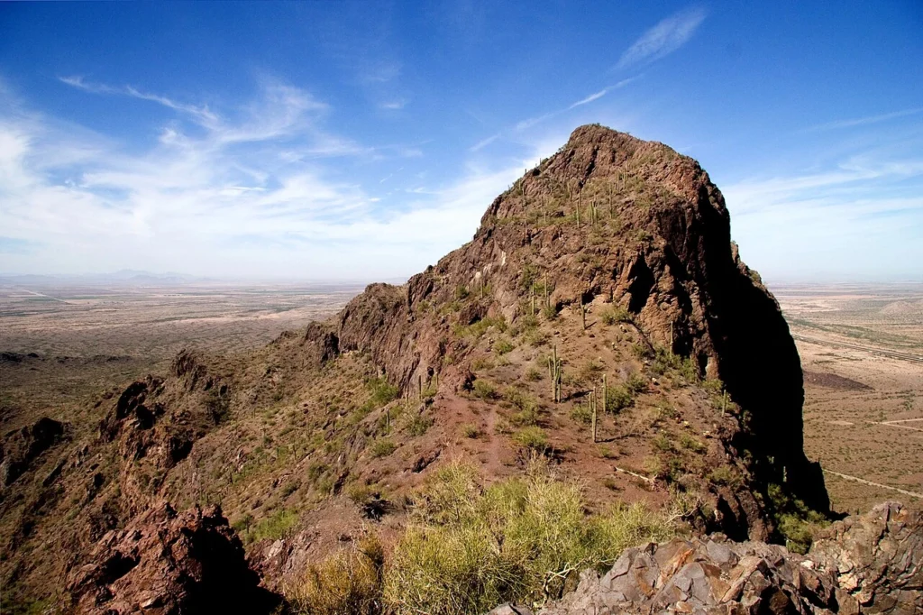
Rising 1,500 feet from the Sonoran Desert floor between Phoenix and Tucson, Picacho Peak is one of Arizona’s most recognizable landmarks — a dramatic volcanic spire that has guided travelers for thousands of years. The 3,747-acre state park preserves a landscape of towering saguaro cacti, challenging cable-assisted summit trails, and one of the most spectacular wildflower super blooms in the American West.
The peak’s distinctive shape results from millions of years of erosion working on a volcanic plug — the hardened lava core of an ancient eruption that resisted weathering while the softer surrounding rock gradually eroded away. The geological process left an isolated spire of resistant volcanic rock rising sharply from the flat Sonoran Desert floor in Pinal County, visible from the Marana suburbs of Tucson 45 miles to the south.
Spanish explorers and gold miners passed through the area, and Union and Confederate soldiers clashed in the westernmost battle of the Civil War — the 1862 Battle of Picacho Pass. The Anza expedition journals document the peak’s role as a navigational landmark for Spanish colonial supply trains that moved mules and donkeys through the pass on routes connecting Mexico to the California territory. The same geography that made it useful as a landmark made the pass a strategic point worth fighting over 87 years later.
What Can You Do at Picacho Peak State Park?
Hunter Trail — summit route: This is a difficult route over challenging terrain, with technical sections. The Hunter Trail quickly and steeply ascends Picacho Peak — the route is steep and twisting, with steel cables anchored into the rock in places where the surface is bare. The Hunter Trail is approximately 2.8 miles round trip to the summit, with an elevation gain of about 1,500 feet from the trailhead.
Gloves are strongly recommended for the cable sections where you grip hand-over-hand to haul yourself up exposed volcanic faces. Dogs are not allowed beyond the saddle area, which is approximately halfway to the peak — those with pets will have to turn back at the cables. Wear proper footwear with ankle support and grip — trail runners or hiking boots, not sandals or street shoes. Pack plenty of food and water before leaving the trailhead, as there is no shade anywhere on the route.
Sunset Vista Trail: The western descent route traverses more gradual terrain, through sparse desert scrub, and offers a different perspective on the peak and the surrounding Sonoran Desert landscape. Used as a descent after summiting via Hunter Trail, it completes the full loop back to the visitor center via the Park Road Loop Trail. The Sunset Vista approach is appropriate for hikers across skill levels who want to experience the park’s terrain without the technical cable section.
Memorial Loop — Battle of Picacho Pass: This short hike loops through desert scrub and cacti to the Battle of Picacho Pass memorial, a stone pillar marking the westernmost battle of the American Civil War. Informational signs are located near the park’s visitor center on Memorial Loop. A second monument nearby commemorates the Mormon Battalion’s march during the Mexican-American War. The combined historical markers make the Memorial Loop the park’s most educational trail — a 30-minute walk through the intersection of three centuries of American Southwest history.
Wildflower blooms: Picacho Peak is one of Arizona’s premier wildflower destinations. When winter rain cooperates, the slopes erupt in stunning displays of Mexican Gold Poppies — bright yellow-orange flowers carpeting entire hillsides — plus lupine, owl’s clover, and brittlebush. Peak bloom is typically mid-March, but varies dramatically with rainfall. A super bloom year draws photographers from around the world. Follow the park’s social media or call 877-MY-PARKS for current bloom conditions before planning a spring visit.
Visitor center: The park’s visitor center houses geological and historical exhibits, a park store, a playground, and picnic areas. Historical markers throughout the visitor center area explain the geological significance of the volcanic plug and the human history of the Picacho Pass corridor from prehistoric Native American use through the Civil War.
Wildlife: Desert wildlife includes jackrabbits, javelina, coyotes, bobcats, lizards, and birds. The bird population is diverse for a desert park of this size — the vegetation transition zone at the base of the peak supports species not found on the flat desert floor.
When Is the Best Time to Visit?
Wildflower season (late February through early April) is the most popular and most spectacular window. Ask locals about the landmark, and most will gush about the spring wildflower super blooms that coat the peak in yellow and orange Mexican poppies. Super bloom years — when significant winter rain and fall rain combine to saturate the soil — produce conditions that fill the trailhead parking lots before dawn. During peak-bloom weekends, arrive by 7 am to ensure entry.
October through February is the best window for summit hiking. Visitors traveling along I-10 in southern Arizona can’t miss the prominent peak. Fall and early winter bring comfortable hiking temperatures in the 60s and 70s, and the park sees its lowest visitor counts outside of wildflower season. The Memorial Loop is a pleasant year-round historical and interpretive walk.
Summer (June through September) brings extreme heat to southern Arizona — temperatures exceed 100 degrees Fahrenheit regularly in July and August. The park stays open, but trail use is limited to early morning. The volcanic rock on the Hunter Trail holds heat intensely. Summer visits should begin no later than 6 a.m. for any summit attempt.
Is Picacho Peak Worth More Than an Overnight Stop?
Many travelers first experience Picacho Peak through the windshield while driving between Phoenix and Tucson, but the surrounding area rewards a longer visit than most people expect. The park’s location along Interstate 10 makes it an easy base for exploring southern Arizona without needing to relocate your RV every day.
A two- or three-night stay gives visitors enough time to hike Picacho Peak during the cooler morning hours, explore the Civil War memorials, enjoy the desert landscape at sunrise and sunset, and still make day trips to Casa Grande, the Arizona City area, or Tucson. Spring visitors can also plan around wildflower conditions instead of trying to catch peak bloom during a single stop.
For retirees, snowbirds, and full-time RV travelers following the I-10 corridor, Picacho Peak often works best as a convenient desert base camp rather than simply another highway attraction.
Where to Park Your RV Near Picacho Peak State Park
Choosing the Right RV Base Camp
The best place to stay depends on how you plan to experience the park.
Travelers who want to wake up next to the trailhead and begin hiking before sunrise will appreciate staying inside Picacho Peak State Park. The campground offers the shortest access to the Hunter Trail and makes it easy to avoid hiking during the hottest part of the day.
Travelers who prefer full hookups, nearby grocery stores, restaurants, and more flexibility may find Casa Grande to be the better choice. Staying just north of the park allows easy day trips to Picacho Peak while providing additional services that many RV travelers appreciate during longer stays.
If your trip is part of a larger Phoenix-to-Tucson journey, choosing a comfortable base camp and exploring the park by passenger vehicle is often easier than moving your RV every day.
Picacho Peak Campground — Inside the Park
The park campground has over 70 shaded electric sites accommodating recreational vehicles of various sizes, with picnic tables and shade ramadas at each site. Modern accessible restrooms and showers serve the campground. Camping WiFi is available.
⚠️ Critical current notice: A water shortage is in effect at the park — no water filling is available at this time. Arrive with full water tanks and all water your rig requires for the duration of your stay. Confirm current water status at 877-MY-PARKS before booking.
⚠️ Booking notice: All stays must be completed by June 30, 2026, per the current Arizona State Parks reservation system. Check azstateparks.com/picacho for updated campground availability and any operational changes after that date.
Reservations are required — no same-day bookings are accepted. Book through the Arizona State Parks reservation system at 877-MY-PARKS or online.
EPIC Arena — Casa Grande via Hookhub
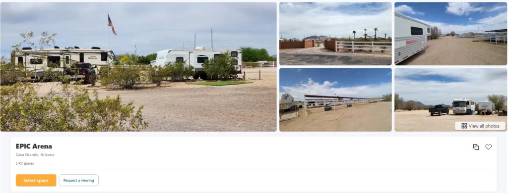
EPIC Arena at 10165 North Blanco Drive in Casa Grande is listed on Hookhub, which produced this guide. The equestrian facility with full hookup RV sites sits approximately 35-40 miles north of Picacho Peak on the I-10 corridor — the most practical private land option for travelers who need water access, a dump station, and confirmed utility connections that the park campground cannot currently provide.
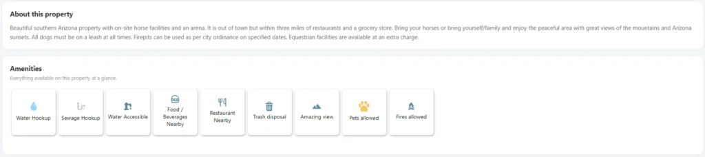
The I-10 midpoint positioning is the specific advantage for Picacho Peak visitors: Casa Grande is equidistant between Phoenix and Tucson, putting EPIC Arena within 35 minutes of the park for day trips in either direction along the interstate. Full hookups — 30-amp and 50-amp electric, water, and sewer — at $8-$35 per night. Spacious southern Arizona property with mountain views and Arizona sunsets. Pets welcome with dogs on leash. Three miles from restaurants and a grocery store for resupply. For any stay during the park’s current water shortage period, EPIC Arena’s full water and sewer hookups make it the most logistically practical base camp in the immediate corridor.
Search current Casa Grande private RV parking for EPIC Arena availability.
What Most Visitors Get Wrong About Picacho Peak
Many first-time visitors assume Picacho Peak is simply a scenic roadside landmark. While the mountain is easy to spot from Interstate 10, reaching the summit is a serious hike that includes steep terrain, exposed sections, and steel cable climbs that require preparation and good footing.
Another common mistake is underestimating the desert environment. Even during cooler months, hikers should carry plenty of water, begin early in the day, and avoid attempting the summit during the hottest afternoon hours.
Visitors also often overlook the advantages of using the area as a base camp rather than a quick stop. Spending two or three nights allows time to hike comfortably, enjoy the park’s history, photograph sunrise or sunset over the Sonoran Desert, and continue exploring southern Arizona without feeling rushed.
Finally, travelers should plan around current park conditions before arriving. Temporary restrictions such as the ongoing water shortage can affect camping logistics, making nearby full-hookup RV sites a practical alternative for some visitors.
Practical Trip Planning
Getting there: I-10 Exit 219 from either Phoenix (~85 miles north) or Tucson (~45 miles south). The park entrance is immediately off the exit ramp — one of the most direct national park or state park access points from a major interstate in Arizona.
Fuel and groceries: Casa Grande and Eloy both have fuel and grocery supplies on the I-10 corridor within 20-30 miles of the park. The park store at the visitor center carries limited supplies — resupply in Casa Grande or Eloy before your stay.
Water: Current water shortage in effect at the park — carry all water needed for your stay. No filling is available on site.
Cell coverage: Reasonable coverage from major carriers at the park off I-10. Coverage may be thin on the upper Hunter Trail sections on the volcanic rock face.
FAQ
How difficult is the Hunter Trail at Picacho Peak?
The Hunter Trail is rated difficult and covers approximately 2.8 miles round trip with 1,500 feet of elevation gain. The final section involves steel cables anchored into exposed volcanic rock that hikers grip hand-over-hand to ascend — it is physically demanding and requires a degree of comfort with exposed heights. Gloves are strongly recommended for the cable section. Dogs must turn back at the saddle — they cannot be taken onto the cables. The Sunset Vista Trail is a significantly easier alternative that provides desert views without the technical summit challenge, and the Memorial Loop is accessible to all ability levels.
When do the wildflowers bloom at Picacho Peak?
Peak bloom is typically mid-March, but varies dramatically with rainfall. The bloom quality depends on the combination of fall and winter rain — a wet fall followed by a wet winter produces the most spectacular super bloom conditions. Check the park’s social media accounts or call 877-MY-PARKS for current bloom conditions before planning a spring visit. During peak bloom years, the trailhead fills before dawn on weekends.
Is Picacho Peak the westernmost battle of the Civil War?
The Battle of Picacho Pass memorial marks the westernmost battle of the American Civil War. The engagement took place on April 15, 1862, when Confederate forces and Union cavalry from the 1st California Column clashed at Picacho Pass. The Union soldiers had marched from California to secure Arizona for the Union. Three Union soldiers were killed in the skirmish. The site is listed on the National Register of Historic Places as the Picacho Pass Skirmish Site.
Ready to plan your Picacho Peak trip?
Find private RV parking near Casa Grande and check EPIC Arena availability before the summer season.