Quick Answers
- Arizona has the longest continuous stretch of historic Route 66 in any state — approximately 400 miles from the New Mexico border to the California border
- I-40 runs parallel to or over most of the original alignment; the surviving drivable sections include Oatman, Seligman, Williams, and the Holbrook corridor
- Private land along the Route 66 corridor through Hookhub starts at $29 per night — listings in Concho and Golden Valley are both within 10-15 miles of the original road
- Williams, Arizona, is the only Route 66 town serving as both an original Mother Road destination and the official gateway to Grand Canyon National Park
- The Oatman section of Route 66 through the Black Mountains is one of the most dramatic surviving original alignments in the United States and is not accessible to large RVs
Route 66 did not become famous by being easy. It ran 2,448 miles from Chicago to the Santa Monica pier, crossing deserts, mountain passes, and empty high plains for travelers who needed a road west and had to build one through some of the most difficult terrain in the country. Arizona’s section — the longest stretch of original alignment that any state still preserves — carries that character intact in places the Interstate never reached.
For RV travelers, Arizona’s Route 66 is a specific kind of road trip: one foot on the historic alignment and one foot on I-40, navigating between the modern logistics of a large rig and the narrow, winding, spectacularly scenic fragments of original road that survive in Oatman, Seligman, and the Williams corridor. The corridor passes within reach of the Grand Canyon, the Painted Desert, and some of the high desert Southwest’s most distinctive landscapes. Overnight stays range from full-service KOA campgrounds to private land in the high desert, at $29 per night.
What Is Arizona’s Route 66?
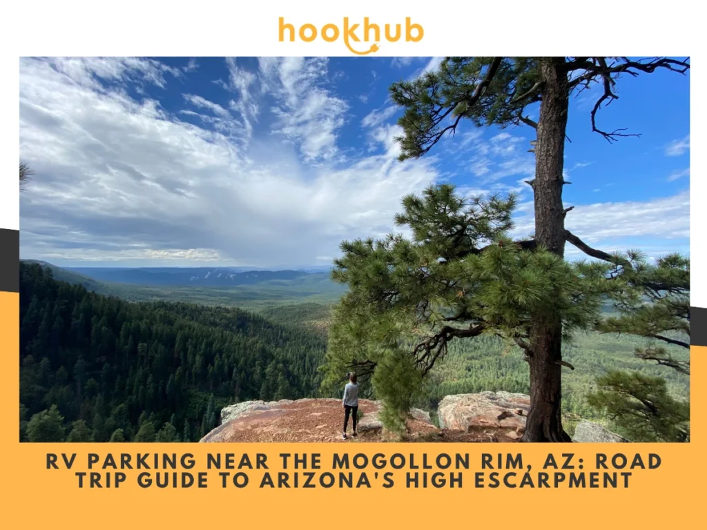
Route 66 in Arizona runs from the New Mexico border near Lupton through the high desert plateau of northeastern Arizona, past the Petrified Forest and the badlands of the Painted Desert, through the college town of Flagstaff at 7,000 feet, down through the ponderosa pine forests of Williams and the Grand Canyon gateway corridor, across the high desert plateau to Kingman, and then over the Black Mountains via the most technically challenging section of original alignment in the entire road — the Oatman grade — before meeting the Colorado River at Topock.
The road was commissioned in 1926 and decommissioned in 1985 when the Interstate 40 alignment made it officially obsolete. Arizona retained more uninterrupted original roads than any other state. The historic portions most relevant to RV travelers: the Holbrook business corridor, the original Route 66 alignment through Williams, and the section from Seligman through Kingman, where the original two-lane road runs through an essentially unchanged mid-20th-century landscape.
The Wigwam Motel in Holbrook — the famous landmark where guests sleep in concrete teepees along the original road alignment — is the first iconic stop entering Arizona from the east. The Wigwam is not a campground but serves as the eastern visual anchor of the famous Route 66 in Arizona and a mandatory stop for photos.
What Can You Do Along Arizona’s Route 66?
Holbrook (eastern end): The Wigwam Motel on Route 66 in Holbrook is the classic landmark photo stop of the entire Arizona corridor — concrete teepees built in 1950 that have become an icon of road-trip culture across the United States. Holbrook’s commercial corridor features Route 66 gift shops, Navajo-owned trading posts with genuine Southwest goods, and the historic downtown that anchors the gateway to Petrified Forest National Park. The I-40 exits here put travelers 20-25 minutes from the park entrance.
Winslow: “Standing on a Corner in Winslow, Arizona” — the Eagles lyric has drawn travelers to the corner of Second Street and Kinsley Avenue for decades. The official “Standin’ on the Corner Park” is a short stop with a mural and a rusted flatbed Ford that makes the photograph easy. Winslow also sits near Homolovi State Park, where Hopi pueblo ruins overlook the desert, and an excellent campground with free showers serves as the best overnight option in the Winslow corridor. The La Posada Hotel — a restored Fred Harvey railroad hotel from 1930 — is one of the finest historic buildings on the entire route.
Flagstaff: The largest city on Arizona’s Route 66, at 7,000 feet, is an unexpected combination of a university town, a dark-sky observatory destination, and an outdoor recreation base. Historic Route 66 runs through downtown as Santa Fe Avenue. Flagstaff serves as the approach point for both the South Rim of the Grand Canyon (80 miles north) and the Sedona Red Rock Country (30 miles south). Multiple RV parks operate in the Flagstaff area, and Fort Tuthill County Park, south of town, offers full-hookup sites in a ponderosa pine setting.
Williams: Williams is the only Route 66 town that also serves as the gateway to Grand Canyon National Park. The Grand Canyon Railway departs from Williams’ historic depot daily. The town’s original Route 66 alignment runs through a preserved downtown where the storefronts look largely unchanged from the 1960s. Williams KOA and several other campgrounds serve the RV market here, and private land on Hwy 180 through Hookhub is available for longer stays.
Williams, Havasupai Falls — the turquoise waterfalls inside the Grand Canyon reached via Havasu Creek — is accessible via the Hualapai Hilltop trailhead, roughly 70 miles north. The permit system is intensely competitive and requires planning, but the Williams base camp serves it.
Seligman: The birthplace of the Route 66 revival movement — local barber Angel Delgadillo’s advocacy in the 1980s directly led to the preservation of this section of original alignment when the I-40 bypass threatened to kill the town entirely. Seligman’s Main Street is essentially a living museum of Route 66 roadside culture, with diners, shops, and a warm welcome for travelers who come specifically to explore the history of the Mother Road.
Kingman: The Mohave Museum of History and Arts features a dedicated Arizona Route 66 Museum exhibit. Kingman serves as the western hub for the Route 66 corridor, with access to Hualapai Mountain Park 20 miles southeast for hiking and camping, and the famous Oatman ghost town 30 miles south via the original mountain alignment.
Oatman: The most dramatic surviving original Route 66 alignment in Arizona descends from the Black Mountains through hairpin switchbacks to this former gold rush ghost town, where wild burros still roam the main street. Oatman is not accessible to large big rigs — the mountain grade is steep, narrow, and winding, with no turnaround room for anything over 25 feet. Smaller travel trailers and Class B vans can navigate it with care. Most RV travelers base camp in Kingman or Golden Valley and drive a tow vehicle to Oatman.
When Is the Best Time to Drive Route 66 Through Arizona?
Spring and fall offer the best conditions for the full corridor. March through May brings cool mornings, mild afternoons, and blooming desert wildflowers in the western sections. September through November offers some of the clearest light of the year for photography on the high desert plateau.
Summer is hot in the lower western sections near Kingman and Oatman — temperatures regularly reach 100-plus degrees from June through August. The higher-elevation sections near Williams and Flagstaff remain comfortable at 6,000-7,000 feet but can receive afternoon thunderstorms during the July-September monsoon season.
Winter is the quietest season in the corridor. Snow is possible in Williams and Flagstaff from November through March, and some businesses in smaller towns reduce hours or close in winter. The starry skies along the eastern high desert sections are at their most spectacular on winter nights.
Where to Park Your RV Along Arizona Route 66
Eastern Corridor — Holbrook to Winslow
Holbrook/Petrified Forest KOA is the primary base for the eastern Route 66 corridor at 102 Hermosa Drive in Holbrook. Full hookups, pull-through sites for large rigs, pool, dog park, WiFi, and friendly staff who provide orientation to both the Route 66 sites and the Petrified Forest park entrance. Year-round operation. The KOA is on the original Route 66 alignment west of downtown Holbrook.
Sun Valley RV Park, east of Holbrook near the I-40 corridor, is a convenient place to rest without the full KOA amenity package.
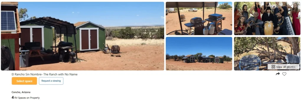
El Rancho Sin Nombre in Concho — listed on Hookhub, which produced this guide — is a private land option approximately 15-20 miles south of the Holbrook/Route 66 corridor. Three pull-through sites at 20 feet wide by 40 feet long with electric hookup and WiFi at $29 per night. Musical hosts, any rig size accepted, gate locked for security. The listing explicitly notes it sits near the Painted Desert and Petrified Forest — the most eastern-corridor-adjacent Hookhub property in the inventory.
Central Corridor — Williams to Flagstaff
Williams KOA and other commercial RV parks in Williams serve the Grand Canyon gateway market. Multiple full hookup sites with 50-amp service, laundry, restroom, and shower facilities, and Wi-Fi in the ponderosa pine forest. Williams is 60 miles from the Grand Canyon South Rim.
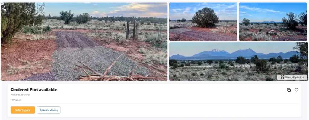
Cindered Plot in Williams is listed on Hookhub. Monthly and yearly bookings only at $827 per month — no nightly option. One acre on a cindered pad less than 500 feet from Highway 180, two large shade trees, and a fire pit. For travelers who want a Williams base camp for an extended Grand Canyon season rather than a single overnight, this is the closest private land option to the original Route 66 alignment.
Fort Tuthill County Park, south of Flagstaff, offers full-hookup camping among ponderosa pines, with a central base for Flagstaff attractions, Walnut Canyon National Monument, and the Flagstaff–Grand Canyon corridor.
Western Corridor — Kingman to Golden Valley
Golden Valley, approximately 10-15 miles east of Kingman on the I-40 corridor, is the private land base camp for both the Kingman/Hualapai Mountain section of Route 66 and the Oatman ghost town approach.
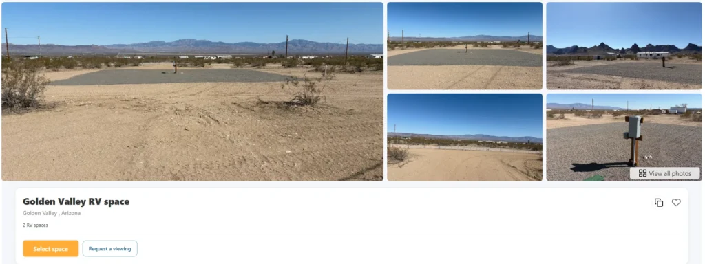
Golden Valley RV Space — listed on Hookhub — has two sites, each 60 feet wide by 100 feet long, on a fully fenced two-acre property with full hookups (water, electric, and sewer) for $29 per night. Pull-through parking. View of the Black Mountain range about 20 miles south. Electric is billed separately from the nightly rate. The site’s location, 10 miles off I-40, puts it equidistant between the Kingman Route 66 corridor and the Oatman approach road.
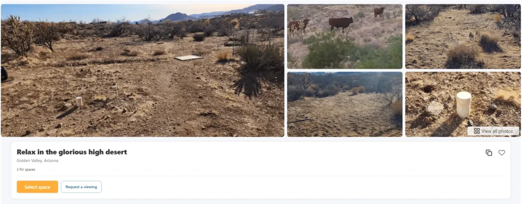
Relax in Glorious High Desert — also listed on Hookhub — is in Golden Valley, with three sites 30 feet wide by 50 feet long, each with a sewage hookup and pull-through access, at $29 per night. Pets welcome; amazing views of the high-desert Southwest from the open site.
Search for current private RV parking in Golden Valley for listings and availability.
Practical Trip Planning
Fuel: Diesel is available in Holbrook, Winslow, Flagstaff, Williams, and Kingman along the I-40 corridor. Fuel is not available in Seligman or Oatman — fill up before reaching either town. Golden Valley has a Flying J truck stop area on the I-40 corridor.
Groceries: Holbrook, Flagstaff, Williams, and Kingman all have full grocery supply options. Seligman has a small general store. Plan all major resupply in the larger towns.
Dump station: Available at the Holbrook KOA and Williams KOA for registered campers. Fort Tuthill in Flagstaff has a dump station. Kingman has commercial dump station access.
Cell coverage: Generally strong along the I-40 corridor. Coverage thins on the original Route 66 alignments away from the interstate, particularly between Seligman and Peach Springs and on the Oatman mountain section.
Oatman access: Do not attempt the Oatman mountain grade in a rig over 25 feet. The original Route 66 switchbacks through the Black Mountains are steep and narrow, with no turnaround space. The recommended approach for large rigs is to base camp in Kingman or Golden Valley and drive a smaller vehicle to Oatman.
Getting there: Route 66 in Arizona is accessible from I-40 at multiple exits between Flagstaff and the California border. The I-40/I-17 interchange in Flagstaff is the central hub. From Phoenix: I-17 North to I-40 West or East, depending on which end of the corridor you want to start.
FAQ
Is the original Route 66 drivable for an RV in Arizona?
Most of it — with important exceptions. The surviving original alignment from Seligman through Kingman is fully paved and drivable for large rigs with no restrictions. Williams and Holbrook also have original alignment sections that accommodate RVs. The major exception is the Oatman Mountain section: the original road through the Black Mountains between Kingman and Oatman involves steep switchbacks, hairpin turns, and a narrow two-lane road that is not safe for rigs over 25 feet. Most RV travelers drive a tow vehicle to Oatman and base camp in Kingman or Golden Valley.
How long does it take to drive Route 66 across Arizona?
The full corridor from Lupton (New Mexico border) to Topock (California border) is approximately 400 miles. Driving straight through on I-40 without stops takes 5-6 hours. A proper Route 66 road trip that includes Holbrook, Winslow, Flagstaff, Williams, Seligman, Kingman, and Oatman, with overnight stops in each major town, takes a minimum of 3-5 days and rewards a week-long exploration. Most RV travelers use I-40 for the highway sections and exit onto the original Route 66 alignment for the historic towns and scenic stretches.
What is the best single-day stop on Arizona Route 66 for an RV traveler?
Williams is the most versatile single stop — it sits on the original Route 66 alignment in a well-preserved historic downtown, serves as the Grand Canyon gateway with the Grand Canyon Railway departure point, and has commercial campgrounds and private land options for overnight stays. For travelers who can only make one stop on the Arizona corridor, Williams offers both the Route 66 heritage experience and access to one of the most significant national parks in the United States in a single day of travel.
Planning a Route 66 RV road trip through Arizona?
Find private land stays along the corridor in Golden Valley, Concho, and Williams, and check current host availability.
